Design and make a better future
Autodesk and Esri, the industry's leading supplier of GIS software and applications, have partnered to transform infrastructure project workflows. Our strategic alliance bridges BIM and GIS, placing critical data at the center of projects. Together, we enable infrastructure owners and the AEC design teams that support them to plan, design, build, and manage a more sustainable and resilient future.

Addressing global challenges
“It is important to consider the needs of future generations during the design and building of projects today. The benefits of our collaboration with Autodesk will include securing sustainable resources for the growing population, a responsible human footprint on our natural environment, better use of our planet’s resources and more resilient cities.”
Jack Dangermond, President, Esri

Unlocking innovations for a more sustainable future
“Partnering with Esri is intended to combine the power of BIM and GIS mapping which will enable our shared customers to build anything, anywhere. Our goals are to provide industry and city planners the ability to design in the context of the real world. This will allow communities to build more connected, resilient cities, and infrastructure with a focused eye on sustainability.”
Andrew Anagnost, CEO, Autodesk
What customer have to say

Arcadis
Integrated data connects teams
"Teams have highlighted the need for robust standards and agreements to connect geographic and building information successfully."
Francois Appéré, Global Autodesk Platform Director, Arcadis

VolkerWessels
Data exchange and collaboration
"An integrated BIM and GIS approach forms the foundation of a project strategy in order to make the data accessible to all project stakeholders."
Jeroen Tishauser, Civil Engineer, VolkerWessels

HDR
Thinking "3D first"
"Autodesk has a set of tools, Esri has a set of tools, and they're very powerful. But when you leverage the tools together, that opens up a world of possibilities."
Cameron Schaefer, Transportation Data Acquisition & Reality Mesh Director, HDR
BIM & GIS Integrations
Connectors for ArcGIS
Desktop integrations enable more seamless flows of GIS data between Civil 3D, InfraWorks, AutoCAD Map3D and Esri's ArcGIS.
BIM & GIS cloud collaboration
Autodesk Construction Cloud and Esri's ArcGIS, together, connects location information, design models, and collaborative workflows for a more holistic view of the entire project life cycle.
Water solutions
Water infrastructure products connected to Esri’s ArcGIS help streamline hydraulic and hydrology model building and management.
Connectors for ArcGIS streamlines the flow BIM and GIS data
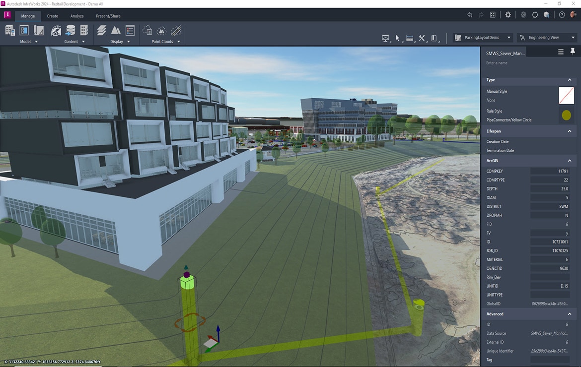
The Autodesk Connectors for ArcGIS maintain a live link between Autodesk design authoring tools and ArcGIS, giving engineers access to the location information they need to have a more solid understanding of existing conditions and the ability to publish the latest data back to GIS.
Autodesk Connectors for ArcGIS
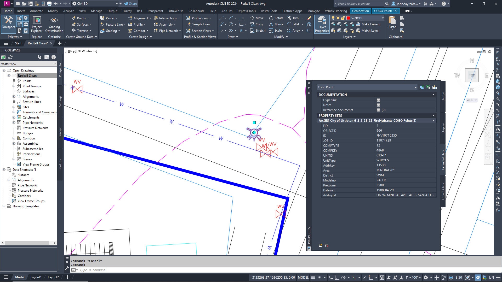
Real time flows of GIS data
Utilize a live link between Civil 3D and ArcGIS to ensure design decisions are based on current existing conditions GIS data. Make updates in Civil 3D based on findings in the field and save those changes back to ArcGIS, ensuring the latest actual conditions information is reflected in the GIS.

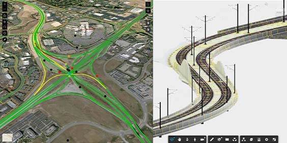
Richer, more accurate project context
Combine GIS data from ArcGIS with InfraWorks models to build conceptual designs that more accurately reflect a project's existing built and natural environment and better visualize how the surrounding area interacts with your project.

Model-based GIS mapping
Create information-rich feature data in AutoCAD Map 3D for visualization, analysis, and planning. GIS data can be curated directly from ArcGIS or you can use publicly available data from others and the ESRI Living Atlas.
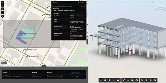
Cloud-connected BIM & GIS transforms design and operations workflows
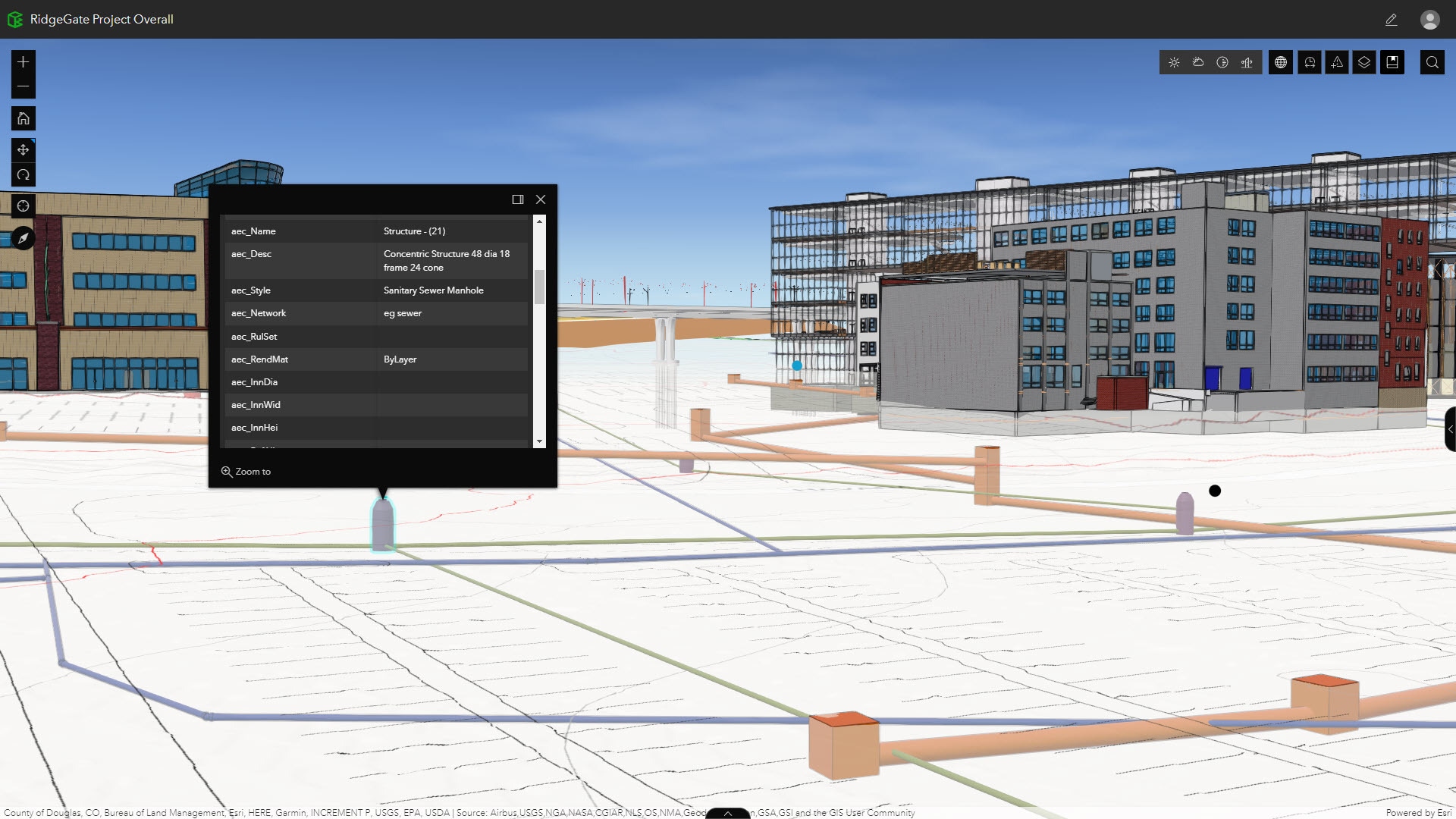
Esri's ArcGIS GeoBIM and Autodesk BIM Collaborate Pro enable design models and location intelligence to be viewed holistically, allowing infrastructure owners and AEC teams to explore and collaborate on an infrastructure asset's information with geospatial context—easing communications and improving decisions throughout the asset’s lifecycle.
Cloud-connected BIM & GIS solutions
Make better design decisions
Link up-to-date project information with geospatial context for improved design review, visualization, and exploration. More complete and accurate information helps ensure the delivery of design documentation in line with design and submissions standards and requirements.
Improve collaboration on design and operations
Connect design documentation to relevant ArcGIS data for access to complete, accurate, and geolocated information of infrastructure assets. Ensure that project stakeholders are working with the most up-to-date information while location intelligence improves assessment that the design project fits the intended use.
Manage design and project complexity
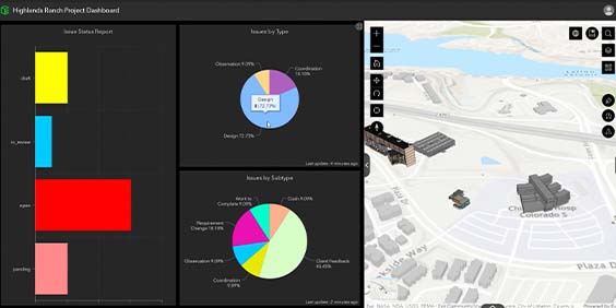
Understand and monitor project status, including issue locations, completion, timelines, and distribution across teams. More efficient collaboration and decision making helps accelerate project reviews while improving environmental outcomes.
Improve capacity for more sustainable operations
Get a clearer view of existing conditions data alongside design data that was used to construct a project. Operations teams gain greater clarity on all aspects of the project in one environment and benefit from access to the most current information.

Make an impact, where it's needed most
Build and maintain collaborative relationships with project decision makers and team members, and effect more active participation and support from the community. With rich visualizations of a project through a web browser, all stakeholders can gain a clear understanding of the impacts of a project.
GIS integrations with hydraulic modeling and cloud technologies for water
Autodesk’s hydraulic modeling and cloud technologies for water are built with powerful integrations with ArcGIS Pro and ArcGIS Online, giving water professionals the geospatial context needed to effectively plan, model, operate, and maintain their infrastructure.
GIS-enabled water solutions
Better understand your water systems
Conduct a wide range of analyses to plan, extend, and manage water distribution systems effectively. With InfoWater Pro built directly on ArcGIS Pro, water modelers can efficiently build and manage models and interpret results in a familiar GIS interface.
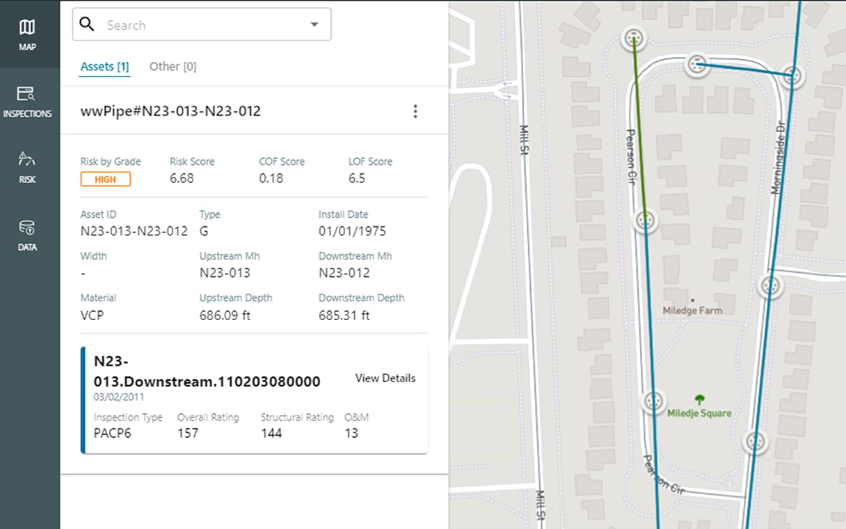
Address the right assets at the right time
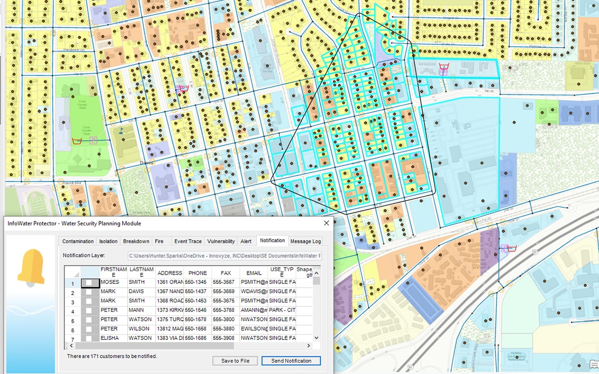
Make informed asset decisions by quickly bringing water and wastewater asset information and geometries from ArcGIS Online into Info360 Asset. Give stakeholders access to rich asset information in a geospatial environment by publishing risk and rehabilitation planning results from Info360 Asset to ArcGIS Online.
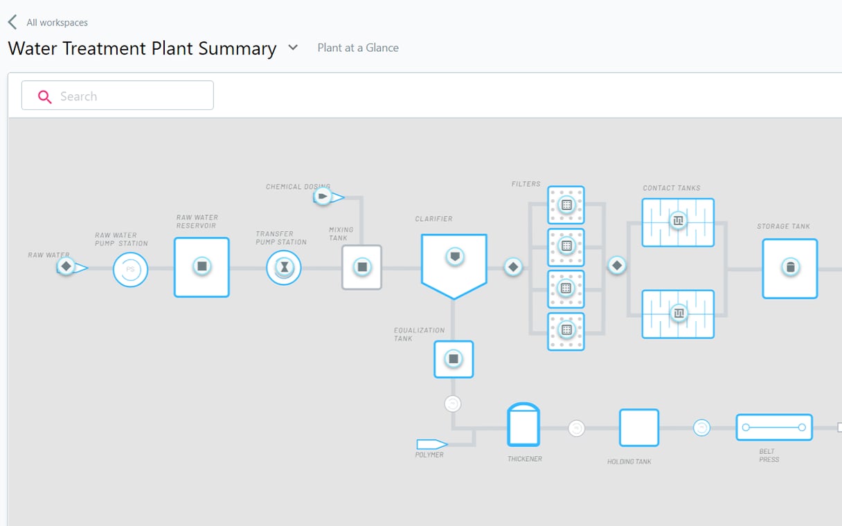
Monitor plant and network operations
Optimize network and plant operational performance and meet regulatory requirements using real-time data analytics. View spatial layers, asset geometry, and geospatial information directly in Info360 Insight and Info360 Plant’s custom analysis and visualization tools.